Endangered Places Around the World
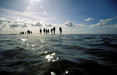
Wadden Sea, DenmarkFormed 10,000 years ago at the end of the Ice Age, the Wadden Sea is a low-lying coastal zone where tourists can walk along a land bridge in shallow water
Congo Basin, Democratic Republic of Congo
Africa’s Mbuti pygmies, who grow to heights of only 4-5 feet, are a group of nomads who live along the Congo Basin, which stretches from Cameroon in the
Kauai, Hawaii
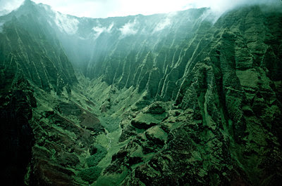
Kauai, the fourth largest Hawaiian island, is famous for its tropical beauty and lush mountains. Global warming could disrupt its distinct “cloud forest” ecosystem, pushing life-giving moisture to higher elevations. Home to the hummingbird-like honeycreeper, a rare and colorful animal that sips nectar from flowers, this cool zone is vital to Kauai’s verdant environment. Deforestation and non-indigenous species like pigs and goats have also decimated the honeycreeper’s habitat in recent years and the bird is now in danger of going extinct.…
Zahara de la Sierra, Andalusia, Spain
Hogh describes Zahara de la Sierra as “a white city in this very green place.” Also known for its olive oil production, the region faces the risk of desert-
Gujarat, India
Gujarat is India’s largest producer of cotton and salt and is also the birthplace of Mahatma Gahdhi. Monsoons will intensify with continued global warming, causing severe flooding and destruction in India. In 1930, Gandhi launched a campaign against the British salt tax, which had made it illegal for Indians to produce their own salt. He eventually won that fight. India is now the third biggest cotton producer in the world after the U.S. and China and the majority of its cotton comes from Gujarat.
The Ganges Delta, India
The paddy fields in the low-lying Ganges Delta are crucial for local farmers as more than 300 million people depend on the crops produced and 130 million actually live there.
Olympia, Greece
The first Olympic Games are believed to have been held in Olympia, Greece, in 776 B.C. The earliest evidence of building at the site is the Temple of Hera, honoring the wife of Zeus, which dates to around 600 B.C. In recent years, extremely warm and dry summers have increased the number of wildfires in Greece. Fires in 2007
Big Sur, California
Stretching for 90 miles along the Californian coast midway between San Francisco and Los Angeles, Big Sur is arguably one of the most breathtaking landscapes in the U.S. For the last 20 years, most of California has been experiencing increased droughts with less rainfall in the spring and summer, leading to a severe escalation in the number of large wildfires
Mergui Islands, Myanmar
The Moken people can dive in deep water for long periods of time. Their underwater vision is also clearer than any other people in the world. Within 30 years, scientists fear that Asia will lose 30% of its coral reefs. Deforestation and increased erosion also threatens the Mergui Island reefs. If the ecosystem collapses, the culture of the 4,000 Moken people could also vanish
Trinidad, Cuba
Founded 500 years ago by the Spanish conquistador Diego Velazquez de Cuellar, Trinidad is renowned for its preserved Spanish colonial architecture and has even been declared a UNESCO World Heritage Site. The once-rich town belonged to wealthy landowners who prospered from the sugar and slave trades. Today, most of their houses—many built by hand—are museums and tourist attractions. “It’s so colorful and lovely,” Hogh remarks. “But because of global warming, the weather in the Caribbean will become more severe with storms. Many of these houses will disappear because they are built by hand and fragile.” Located in the Caribbean Sea, Trinidad, together with the rest of Cuba, lies in the path of hurricanes. In 2008,
Mississippi River Delta, United States
The Mississippi River Delta, with its rivers, marshes and barrier islands, provides a habitat for many species of birds, fish, shellfish and small mammals. At the rim of the delta, the Chandeleur Islands form a chain that acts as a buffer zone against hurricanes and storm surges for the densely populated regions of Louisiana and Mississippii. But ferocious storms, like 2005’s Hurricane Katrina, have greatly reduced the islands’ defenses. Storms and hurricanes are expected to grow even fiercer in the future with global warming, leaving the local environment and vital culture more exposed to destruction.
Yangtze River, China
Stretching for 3,900 miles, the Yangtze River is the longest river in Asia, surpassed only by the Amazon in South America and the Nile in Africa. The agricultural area of the Yangtze generates almost half of the total crop production in China—in total, China accounts for about a third of the world's rice production. Roughly 500 million people depend on the river for fresh water, including those living in Shanghai and Nanjing. Due to the diminishing of the Tibetan glaciers, the flow of the once mighty Yangtze is dwindling. By the end of the 21st century, the United Nation's IPCC projects that those glaciers will have decreased by more than 60%, deeply impacting the Chinese people and the world's food supply.
Kitzbuhel, The Alps, Austria
Esteemed as a winter wonderland, Austria and the Alpine region is Europe’s snow resort Mecca. It’s also gorgeous in summer with its evergreen pastures and cascading mountainsides, made famous by the classic Hollywood musical 'The Sound of Music.' “Everyone here in Europe is used to going there, for skiing,” Hogh explains. “They’ve been skiing there for the last 200 years and some of the country is less and less snow.They try to make snow with snow cannons. You’re not allowed to heli-ski as much anymore because of the pollution. It will go down by 80% of its normal size. Will my children be able to ski there? I don’t know.'
The Battery, New York City, United States
The southern shoreline of Manhattan Island, known as the Battery, is the largest public place in downtown New York. Hundreds of thousands work nearby and over 36,000 residents live in its surrounding area. About every 100 years, the area experiences extreme flooding that reaches heights of up to 10 feet. Climate change is expected to increase the frequency of winds and hurricanes and cause sea levels to rise. According to the worse-case scenario, extreme events may occur every four years by 2080, with floods raising water levels by 11-14 feet and paralyzing the whole Manhattan infrastructure. “The tidal area there with the Hudson River is a very beautiful place but it will go underwater,” Hogh warns. “There is more than 280,000 people working in this walking district.
Tuvalu, Pacific Ocean
Located between Australia and Hawaii, in one of the most remote areas of the Pacific Ocean, lies the nation of Tuvalu. Only 10-square miles – made up of tropical reef islands and narrow coral atolls encompassing blue lagoons -- Tuvalu is the fourth smallest country in the world. Only 12,000 people inhabit the nine-island nation. At 16 feet above sea level, the country has one of the lowest maximum elevations in the world, making it extremely vulnerable to storms and changes in sea level. Tuvalu is also affected by the King Tide, a high tide that raises the sea level higher than normal. Coupled with the expected rise in global sea levels, the entire nation could ultimately become submerged. “I don’t care whether the place is big or small,” Hogh concludes. “It’s the same thing with people. No matter if you’re black or white or Chinese or whatever. It’s about treating each other with respect and it’s the same thing with these small islands.


